The Windmill
Stapleford's windmill
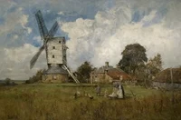
Stapleford's windmill has always been something of a mystery. It is not clear why one was needed, since the water mill on the river Erewash should have served all the requirements of the village without the inconvenience of carting bags of grain up to a windmill at the top of Toton Lane but perhaps the water mill had fallen into disrepair.
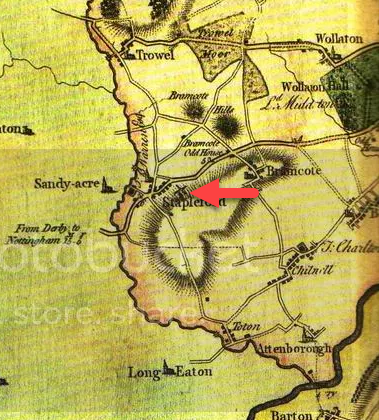
The evidence for Stapleford having had a windmill in the past comes from three sources. Firstly, a windmill is shown on Chapman's map of 1774, [1] secondly, in the Enclosure Award of 1772, one of Stapleford's open fields is named 'Windmill Field'[2] and thirdly, on Ordnance Survey maps the area at the top of Toton Lane is called 'Windmill Hill'.
Chapman's map of 1774 shows a windmill which seems to be situated on the high ground looking down on Nottingham Road just to the east of the Pinfold Lane junction with Nottingham Road near St. John's School. This is not, traditionally, where the windmill was thought to have stood, on Windmill Hill, and whilst there might be a number of explanations for this, there is no firm evidence to support one as against another.
The Enclosure Award of 1772 lists one of the open fields as 'Windmill Field' but there is no indication of a windmill on the map accompanying the award. This open field, situated between Toton Lane and Nottingham Road, was also called 'Clouds Field' and was known by this name in 1695. By 1716 it was known as 'Windmill Field' and this gives us some idea of the date when the windmill was first in use.[3] Apart from these three facts nothing else is known. It was probably a simple post mill which, being made of wood, only lasted a few years and left no remains, perhaps similar to the Cat and Fiddle at Dale Abbey but without the stone roundhouse.
Stapleford's other windmill
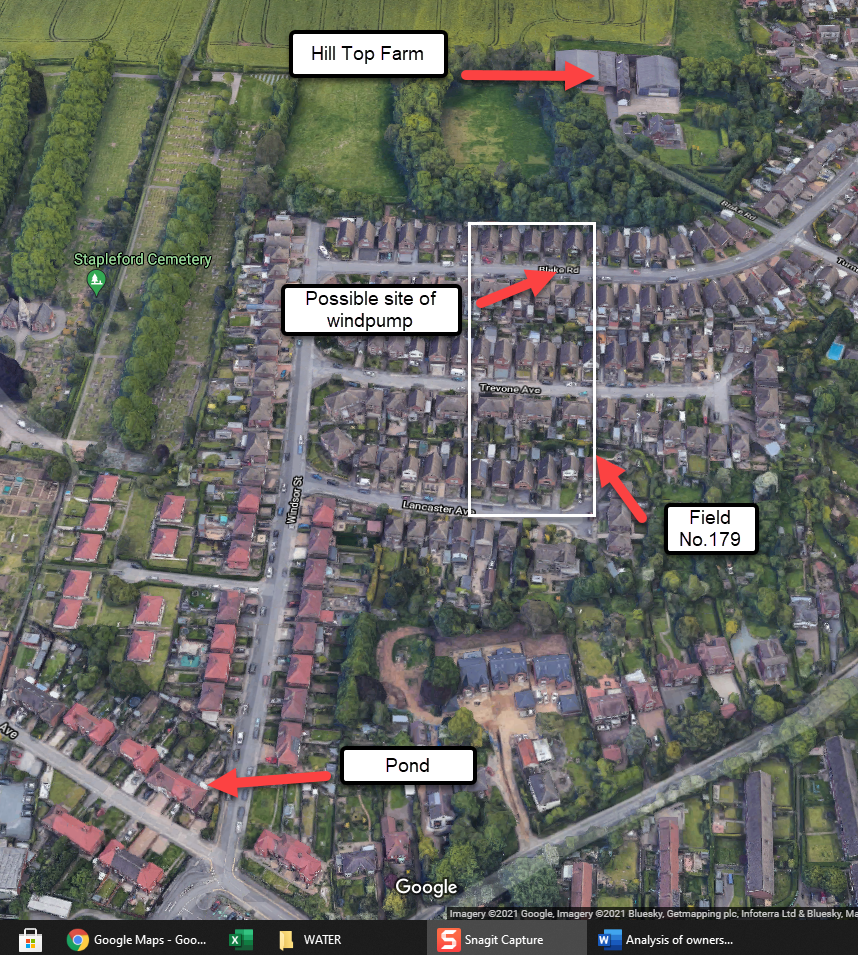
Stapleford's 'other' windmill appears to have been a windpump erected near Hill Top Farm, Toton Lane, whose purpose was to provide water for the farm animals. There is a lot of anecdotal evidence testifying to its existence and many people can remember seeing it but precise details of its design, site, purpose and the source of water are hard to come by.
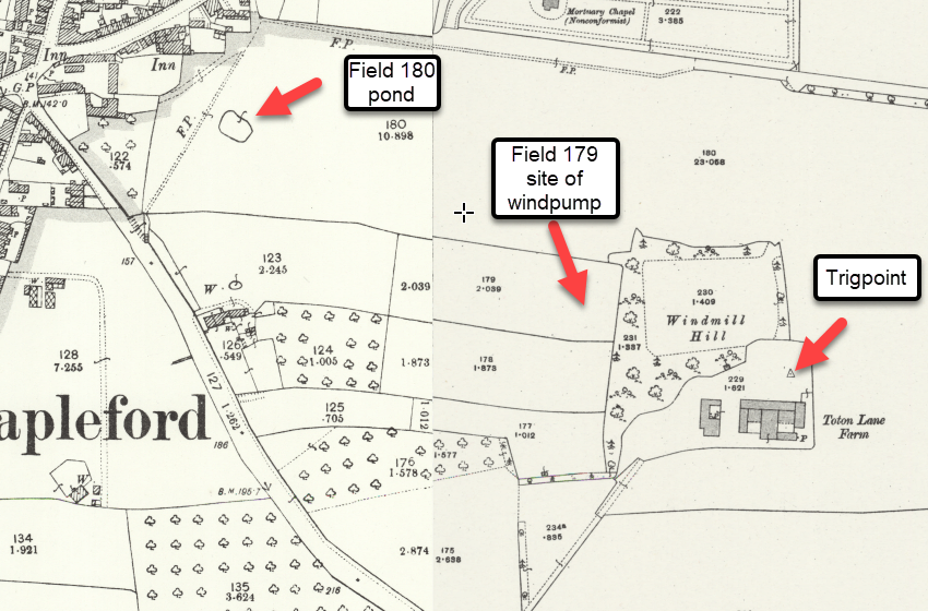
The documentary evidence for this windmill comes from the sale catalogue when the Stapleford Estate, including Hill Top Farm, was sold in 1919. The farm, including field No.180, was sold as Lot 1 and the sale particulars said that Lot 1 included a wind-mill in field No.179, although field No. 179 itself was being sold separately as part of Lot 3.
The conditions of sale stipulated that the purchasers of Lot 1 had the right to 'enter upon field No.179 for the purposes and keeping in repair the Wind-mill and existing line of pipes leading from the Wind-mill to field No.231 and shall, at all times keep in good repair, working order and condition, the line of pipes on field No.180 as to preserve the supply of water as at present enjoyed for Lot 3.' The purchaser of Lot 3, which included field No.179, had the right to obtain water from the pipe in field No.180 and had to grant access rights for the maintenance of the wind-pump which was on his land but not owned by him.
The wind-pump seems to have had two sets of pipes. One going to field No.231, presumably carrying the supply to the storage tanks and the other passing through field No.180, presumably to the source of the water. The sale particulars for Hill Top Farm show that it had three large water storage tanks.
Further documentary evidence arises from a conveyance of land in 1927 when a plot was sold for the building of 25 Toton Lane. The title contained a covenant not to build over the water pipes that crossed the land running from the windmill to the land south of the property.[4] This was probably the supply running from the pipes in field No.180 to the property comprised in Lot 3 of the sale particulars.
In the absence of other facts we can only speculate about other details. Firstly, the site. We know that it is field No.179. It would probably be up at the top of the field to catch the wind but not too close to the trees in field No.231, which was and still is a small wooded area. Best guess is that it would be somewhere in front of house numbers 11-21 Blake Road.
Secondly, the purpose. One contributor states that its purpose was to provide water for the cattle. Whether it ever provided drinking water for the house is a matter of conjecture. The farmhouse was built in 1902 [5] which was eleven years after the date when the Stapleford and Sandiacre Water Co began laying their mains. Unfortunately, Hill Top Farm was probably one of the houses that they could not reach as it was higher than the company's reservoir on Rushy Lane.
Thirdly, the design. Whilst many people can remember a windmill no one has described it. It was probably of a type first made by Thomas Perry in America in 1888 with a lattice steel tower, a slatted fan wheel and a rudder like tail. It did not have, as has been pointed out by those who remember it, the four large sails of a conventional windmill.
Fourthly, the source of the water. It may have been a well but the extraction of water when the pump was activated would probably have soon drained it. The more likely source would be the pond shown on the map at the lower end of field No. 180. This field was part of the farm and the water would be free and reasonably reliable. A pump of the type referred to above would be fully capable of lifting water from the pond, which is approximately 90 ft. lower than the probable site of the windpump.
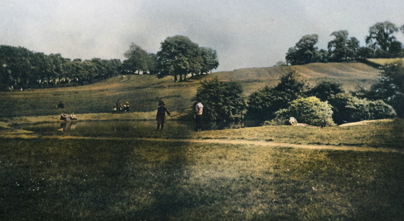
This well-known idyllic scene in rural Stapleford shows this pond on Cliff Hill, usually called 'Back o' Sammies.' The trees on Windmill Hill can be seen at the top right of the picture and field No. 180 ( a good sledging hill in the winter) stretches to the top of the skyline. The pipes ran down this field. A small corner of field No. 179, in which the windpump was situated, can be seen at the top right of the view.
Fifthly, when was it in use? At best we can say the early years of the 20th century but the dates when it started and ended are unknown. Hill Top Farm wasn't built until 1902 and by August 1928 the pond had been filled in with ashes, tin cans, bottles and night soil and was described as a "dirty, black and green mess of filthy water." If that was the source of the water then it's use must have ended before that date. The Council were planning to build houses on the site.[6]
Subsequent house building.
Most of this land has now been built over. Field No. 179, in which the wind-pump stood, is outlined in white in the above aerial photograph. House nos. 11 to 21 Blake Road form the eastern boundary and back on to field No. 231, then and now a small wooded area. In addition, the field would also have included 10-20 Blake Road, 5-10 and 33-38 Trevone Avenue, and 5-10 Lancaster Avenue. The western hedge line would have run down the middle of Lancaster Avenue. Windsor Street runs down the middle of field no.180 and the pond from which the water was pumped is now occupied by 10-16 Cliffe Hill Avenue. The trigpoint is still there, deep in a hedge.[7]
Many questions remain unanswered. Send an email if you can add anything to the above, info@staplefordlocalhistory.org.uk