Water Supply
Geologically, Stapleford can be split into three areas. The first area is the high land to the south east of the old Nottingham and Derby Road and to the north east of Ilkeston Road. The bedrock here is the Lenton Sandstone Group, previously known as the Bunter sandstone. The second area, to the west, is the flat alluvial land of the Erewash Valley. The third area, the rest of the parish between the Erewash and the high land, is on the Lower Coal Measures. Wells dug into the sandstone produce water of a satisfactory quality while those that are on the coal measures or the alluvial plain produce poor quality water.
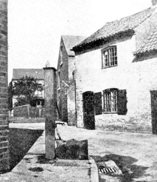
Before the coming of piped water people relied on their own wells or on a communal well or pump. The parish pump was on Nottingham Road at the junction of Church Walk and when the new Parish Council met in 1895 one of its first functions was to establish a list of parish property. The Parish Pump was on that list.[1]although at that time it was actually dry,

There was another source of water on that list and that was the 'Healing Well' used by the people of New Stapleford, near Fields Farm on the Trowell border. The name is very often misrecorded by clerks not familiar with its etymology and here it is recorded as the 'Ealey Well.'[2] It was found, on investigaton, to be on the other side of the Trowell Sick Dyke and hence in the parish of Trowell
In 1877 the health of Stapleford was giving such concern that the Local Government Board sent its own inspector, Dr. Richard Thorne, to report on the health of Stapleford. Thorne was an eminent physician, later to become the principal medical officer of the Local Government Board, and his report was damning. "Throughout the greater part of Stapleford the water is obviously foul, or is subject to the constant risk of pollution." Amongst his many recommendations was that an ample and wholesome supply of water should be provided throughout the village.


The search for water began in the hamlet of Wilshorpe between Sandiacre and Long Eaton in June 1889 but was abandoned at 371 feet owing to the hardness of the water. Further borings were made and finally water was found in abundance at a site on Derby Road, Sandiacre, next to the Methodist chapel. Water was pumped up at a rate of 240,000 gallons a day without any diminution of the supply and the water works was established here.[3] A service reservoir with a capacity of 70,000 gallons was built on Rushy Lane at a height of 253ft. above sea level and 11 ½ miles of main were laid. The height of the reservoir was sufficient to provide pressure for most of Stapleford except for the farm at the top of Toton Lane which was just a few feet higher. This installed its own windmill to lift water from a pond at the junction of what is now Cliffe Hill Avenue and Windsor Street through pipes which ran under what became the gardens of houses on Toton Lane.
The business was incorporated as "The Stapleford and Sandiacre Water Co." in 1891 but progress in the installation of a piped water supply was slow. The Directors reported that "they had considerable prejudice to contend against. It takes time to induce people to abandon their wells." The number of houses connected was as follows:- 1891-42, 1892-129, 1893-49, 1894-109, 1895-89, 1896-85. The population in 1891 was reported by the Directors as 7,000. It is obvious from the Directors' Report that there was not a great enthusiasm to have piped water installed. However, the company was clearly undercapitalised and seemed to be trying to extend the system purely from current income. Little information is available for the following years. In 1913 the Parish Council complained that the water was "filthy" and when the proposal was mooted for the local authority to buy the company out we learn something more of its then plight, "The supply of water is both inadequate and unsatisfactory."
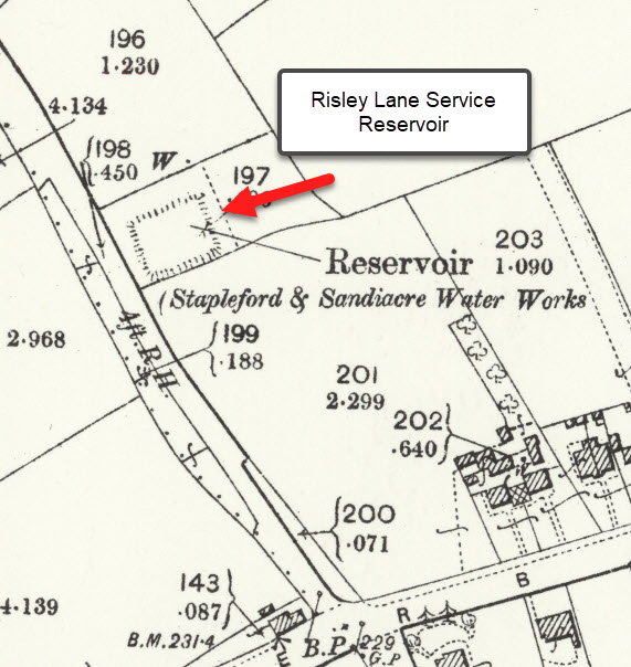
In 1921 the directors intimated that they would be prepared to sell the company and in 1927 it was bought jointly by the Shardlow Rural District Council and the Stapleford Rural District Council for a purchase price of £12,063 2s.7d.. A new engine was purchased from Messrs. Crossley Bros. for £280. Attempts were made to increase the water supply but the obvious area of sandstone in Bramcote was within the supply area of the Nottingham Corporation and would be opposed by them and other areas, such as the coal measures, were not suitable for use.[4] A supply was requested from the Derwent Valley Water Board, whose Leicester main ran through the parish of Risley and a reservoir with a capacity of 100,000 gallons was constructed on Hopwell Lane, Risley, built by Fletcher & Co. of Mansfield costing £5,998 9s. 4d. The Derwent Valley Water Board main was tapped on the 10th February 1930 to fill the new reservoir and 45,000 gallons of the soft Derwent water were bought daily and mixed with the local hard water suppled by the Sandiacre Pumping Station.[5] This supply was not guaranteed after 1935. [6]In the end it was decided to ask the Nottingham Corporation to supply water to Stapleford. After some negotiation a sum of £8000 was agreed [7] and notice was given to Shardlow to terminate the agreement.[8] It was decided, no doubt for administrative convenience to sever the water main on the boundary on the 25th December 1931, Quarter Day. However, wiser counsels prevailed, preparations for Christmas dinner were not disrupted and plans were made to cut the main on the 21st. or the 22nd. December 1931.[9] There was some dispute as to how to supply that part of Stapleford to the west of the Erewash as Shardlow refused to allow Nottingham to run a new main down Station Road but this was eventually resolved.[10]

Nottingham Corporation had been making plans for the takeover and in November 1928 had petitioned Parliament for permission to build a service reservoir at Bramcote and to lay a pipeline for its supply from its system at the junction of Abbey Bridge and Gregory Street. A connecting main from the reservoir would also need to be laid to connect with the Stapleford system at the parish boundary in order to supply the town.[11]
The supply from the Nottingham system was softer than the Risley reservoir and took "25% of the hard labour out of washday."- Notts. Archives, PAC/79/1/1. Stapleford Parish Council Minutes 1895-1897 27th March 1895
- Notts. Archives, PAC/79/1/1. Stapleford Parish Council Minutes 1895-1897 27th March 1895
- The Geology of Stapleford and Sandiacre. J Shipman. p.18
- Notts. Archives, DC/ST/2/4/1. Stapleford & Shardlow Joint Water Committee 1927-1933 p.22
- History of the Shardlow Rural District Council Water Undertaking, F.Haynes. (to be found in the Report of the Medical Officer for Health,1955 Copy in the Wellcome Institute.)
- Notts. Archives, DC/ST/2/4/1. Stapleford & Shardlow Joint Water Committee 1927-1933 p.22
- Notts. Archives, PAC/79/1/10. Stapleford Parish Council Minutes 1931-1932 p. 60
- Ibid p.54
- Ibid p.132
- Ibid p.120
- The London Gazette 27 November 1928, p. 7821