Pinfold
Stapleford’s pinfold, used historically for the impounding of stray animals, was an unremarkable structure, especially when compared with the more substantial and better-remembered example in the neighbouring village of Sandiacre. Despite remaining in existence until at least 1924, no photographs of it are known to survive.
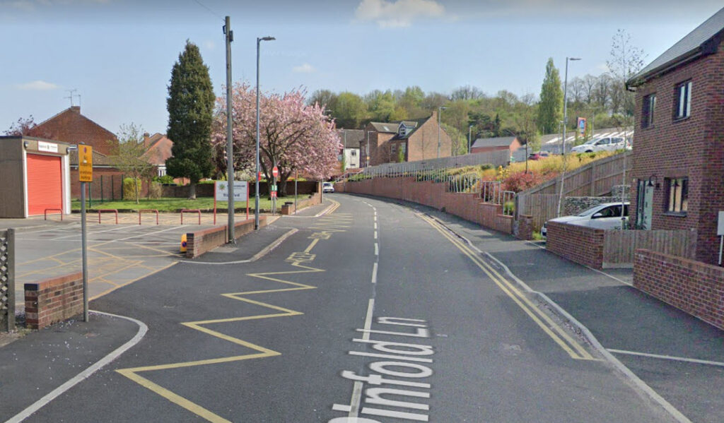
The precise location of the pinfold has long been a matter of uncertainty. It was generally assumed to have stood on the site later occupied by the car park of the Nags Head and Plough, enclosed by a substantial stone wall backing onto Pinfold Lane. However, this assumption is at odds with frequent contemporary references to the pinfold’s dilapidated condition, which suggest a less robust structure.
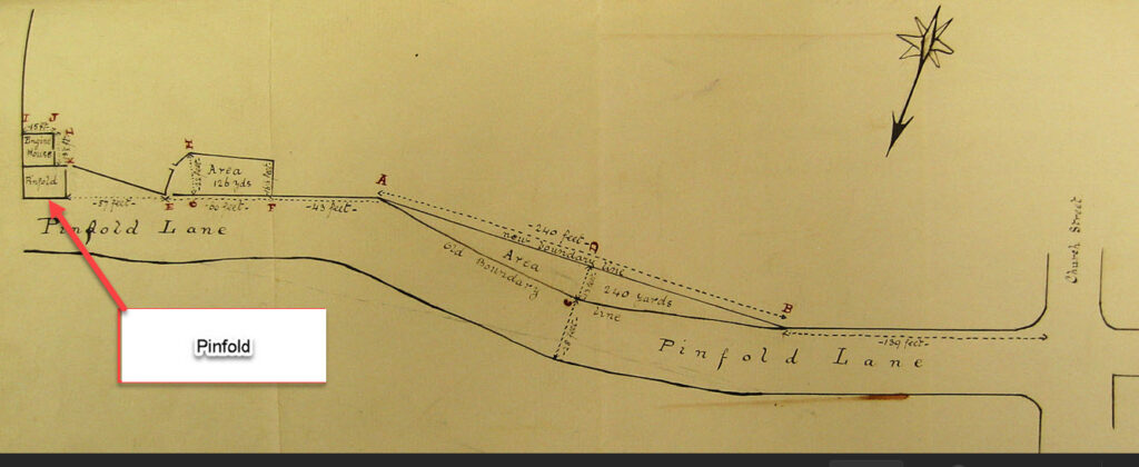
The enclosure award map does not depict the pinfold directly, but its approximate location can be deduced from a description in the award itself. One parcel of land—No. 19—allocated to Isaac Burton, is described as being bounded on one side by the pinfold.
The copy of the enclosure award held by Nottinghamshire Archives is not the original, but a transcript prepared in 1844 for John Palmer, who was then the parish’s Junior Surveyor of Highways. Inserted into the back of this bound volume is an unrelated document, likely placed there by Palmer himself, recording a conveyance of land made in February 1870 when Pinfold Lane was widened. At that time, Palmer was serving as parish waywarden. Accompanying this conveyance is a detailed plan showing the pinfold located in front of the parish engine house. The plan includes precise measurements, allowing the distance from the pinfold to Church Street to be calculated as 539 feet. This corresponds with the present-day location near the fire station; the pinfold would have stood opposite the building now housing the fire appliance.
Historical Background
The earliest known reference to the pinfold appears in the Constable’s Accounts for 1651, which record a payment of two shillings to George Jackson for timber to repair the structure, one shilling and fourpence to the workmen engaged in the repairs, and incidental expenses of fourpence for “drinke” and twopence for nails.[1] Minor maintenance costs recur in subsequent years, although in 1665 a major refurbishment was undertaken, funded by a local levy.[2] When the Parish Council assumed the secular responsibilities of the vestry in 1894, one of its first actions was to take charge of parish property, including the pinfold.[3] In 1896 the Shardlow Rural District Council proposed building on the site, intending to erect a storage room for the street water van and a meeting place for the Parochial Committee.[4] A protracted dispute over ownership ensued. The Parish Council claimed the land was theirs, a position endorsed by the Local Government Board. Refusing to relinquish its claim, the Council effectively blocked the project, which was abandoned in October 1897.[5] In January 1899 the Parish Council attempted to sell the site to the owner of an adjoining property, again seeking guidance from the Local Government Board. A joint meeting of the Parish Council and the Rural District Council concluded that the legal costs involved in proving title would outweigh any proceeds from the sale. It was resolved that the matter be left in abeyance.[6] In 1909 the Parish Council drew attention to the dangerous condition of the wall or fence surrounding the pinfold.[7] Later that year, a proposal to use the site for a public urinal was rejected.[8] No further developments occurred for thirteen years, until June 1922, when the Rural District Council discussed the pinfold and a right of way across part of the site. The matter was referred to the Chairman and Surveyor for further investigation.[9] In January 1924 the Surveyor was instructed to purchase corrugated iron sheets to roof the pinfold.[10] This prompted a complaint from Mr W. Naylor of Pinfold Lane, who requested that the Council vacate the site and cease using it to deposit road materials. The Council responded that they had used the site without restriction for the previous twenty years and asked Naylor to remove a fence he had erected across it.[11] In April of the same year, the Lord of the Manor, Major Holden, intervened, asserting that the pinfold was part of his estate and had been used by the Council without permission from himself or his trustees.[12] No further reference to the pinfold appears after this date, and it may be assumed that the site was quietly incorporated into the land later sold for the construction of the Carr Fastener factory, and subsequently redeveloped as the Aldi supermarket.Footnotes
Click to return to main text
- Constables Accounts 1651
- Constables Accounts 1665
- Stapleford Parish Council Minutes 1894-1897 27th March 1895
- Stapleford RDC Minutes 1895-1899 p.70
- Ibid p.125
- Stapleford RDC Minutes 1899-1902 p.115
- Stapleford Parish Council Minutes 1907-1910 p.100
- Stapleford RDC Minutes 1907-1909 p.210
- Stapleford & Sandiacre News, 24 June 1922,
- Stapleford RDC Minutes 1923-1925 p.100
- Ibid p.124
- Stapleford RDC Minutes 1923-1925 p.135