Church Lane - part one
Introduction: Scope, Method, and Sources
This section examines the history of Church Lane, Stapleford, with a particular focus on the individual houses and their occupants over time. Church Lane, situated in the historic core of the town, forms part of a settlement pattern that predates much of Stapleford’s modern expansion. The principal aim is to trace the development of the street and to identify, as far as the surviving evidence allows, the individuals and families who lived there. It should be stated at the outset, however, that the available sources do not permit a fully conclusive or continuous reconstruction of Church Lane’s residential history. Instead a range of fragmentary records have been used in the hope of providing a reasonably coherent narrative. Some degree of conjecture has inevitably been required, and it is recognised that alternative interpretations are possible. The range of sources on which this section is based will also be considered together with an account of the methodology. This will give some indication of the limitations, gaps, and potential pitfalls encountered in working with the surviving evidence. It is hoped that by making these issues explicit, the judgements and conclusions offered may be more clearly understood and more easily assessed. To avoid an excessive use of footnotes in the main text, references are given in detail here and referred to more briefly where appropriate in the narrative. The sources fall into several broad categories. Chief among them are the decennial census returns from 1841 to 1911, which offer snapshots of the resident population, albeit with known limitations regarding accuracy and address identification. The 1939 National Register supplements these for the interwar and early wartime years. I As will become apparent, the interpretation of this material has not been straightforward. Numbering systems changed over time, house names appeared and disappeared, and in many cases properties were rebuilt, divided, or amalgamated, making longitudinal study particularly challenging. Yet despite these difficulties, it is hoped that the following account will contribute to our understanding of Church Lane’s social history, and more broadly, to the residential and community life of Stapleford from the nineteenth century onwards.Development by the Rev. William Chambers, D.D. in 1773
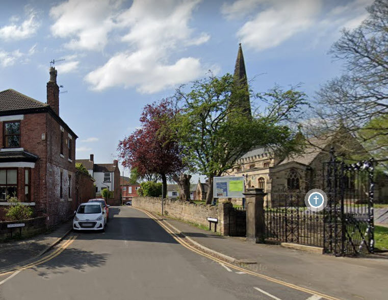
Church Lane can be reasonably dated to about 1773 when the Rev. William Chambers, D.D., one of the largest land owners in Stapleford, opened an account in his Rent Book for the building of a new farm in Stapleford for the occupation of Jacob Hichinbottom.[1] After the Enclosure Award of 1772, Chambers owned most of the land around the church and chose a spot on the high ground just behind it to build his farm. Needing a way for his carts to get through to Church Street he probably made a track along by the side of the churchyard to enable them to travel back and forth. Prior to this, Stapleford churchgoers, as they reached the cross, would come to a narrow triangular grassy area on their left, bounded on one side by the hedge of the last house on Church Street and on the right by the hedge of a house near the churchyard, and would see the gate to the church about half way up on the right.
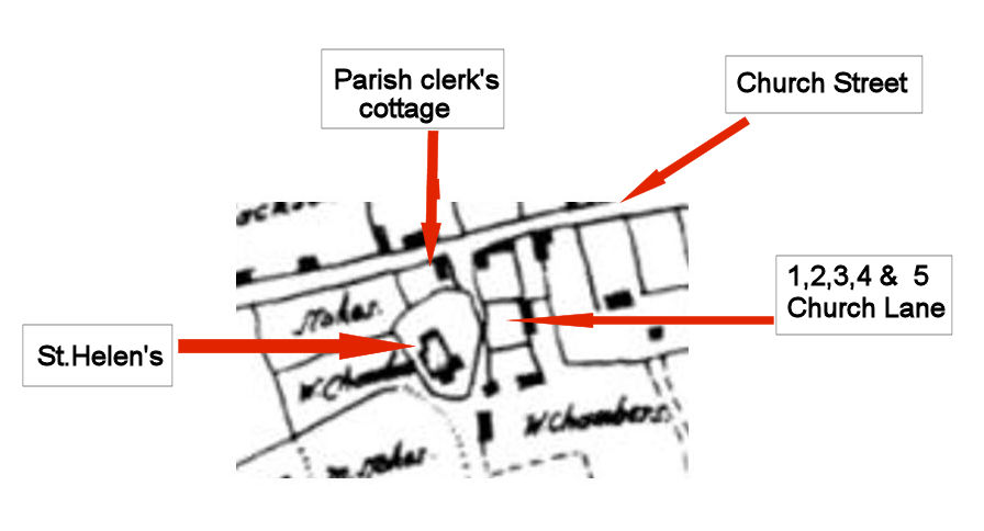
Church Lane in 1888
The 25″ Ordnance Survey map 1st edition, surveyed in 1888-89, was a timely product for Stapleford as it captured the town at a point when it had started to grow rapidly but before the old buildings of the Stapleford Hall Estate were demolished. This map is on the National Library of Scotland website link.
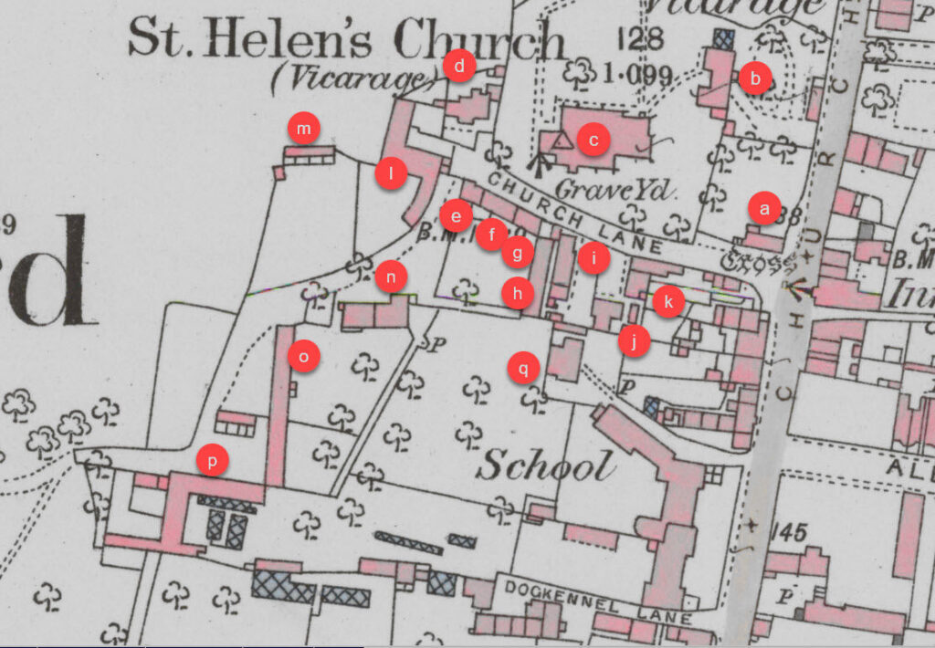
This map shows that there were ten houses on the lane in 1888, eight on the left hand (south) side , labelled ‘i’, ‘j’, ‘k, ‘e’, ‘f’, ‘g’, and ‘h” and two on the right hand (north) side near to the church tower, labelled ‘d’. In addition there was a cottage, known as the parish clerk’s cottage, near the cross, and the vicarage, which was just a little further down Church Street. The last three houses on the left on Church Lane, two of which were later infills, and the two cottages near the tower belonged to the Stapleford Estate. The others were privately owned and it seems likely that the block of cottages, Nos.1 and 2 at right angles to the lane, Nos. 4 and 5 also at right angles and No.3 across the end, were all built at the same time on the parcel of land shown on the enclosure award map just south of the church.
Other sources.
Census Returns
The census returns for 1841 to 1911 are online and give a detailed listing of the names of those who were living on Church Lane at the date when each census was taken. Unfortunately, it is not until 1911 that the houses are numbered and, whilst it is possible in some cases to extrapolate backwards, the allocation of names to a particular building is difficult. George Hampson at No. 3 can be traced back from 1911 to 1891 and the Browns at No.6 can be traced back to 1861. Elsewhere the Barrowcliffes can be traced from 1841 to 1881. However, more work needs to be done to establish the precise nature of the relationships from year to year and the houses in which they lived and this will certainly throw more light on this community.
The main problem in the use of the census returns is in establishing the order in which the enumerator recorded the houses. The details of the Church Lane houses, and usually the houses on Church Street immediately preceding and after Church Lane, have been extracted. Ancestry has been used for this and the references are those that are used on that website. For each year an attempt has been made to work out the order of the walk, but this is not always clear, particular when those living in distant houses on the estate and at the mill are included. There were probably occasions when names were recorded out of order and cases when families moved into other homes on Church Lane between census.
Stapleford Hall Estate sale particulars 1856
The Stapleford Hall and other estates of Admiral Sir John Borlase Warren were eventually devolved on his great grandson William John Vernon. Some idea of his character can be gained from his autobiography [2] where he comments on the sale of Stapleford and Toton.
“It was, I think, in October that my estates of Stapleford and Toton were sold, and sold very well. I did not finally sell Stratton Audley until a year or two afterwards. These sales made me comparatively very well off, but unfortunately I was very extravagant, and spent a great deal more money than I ought to have done, in consequence of which I have been more or less crippled during my subsequent life.”
A first sale took place in October 1855 when the Toton Estate was sold, but the Stapleford Estate did not sell and was put up for sale again in 1856. It is the particulars of this sale and the accompanying map which are held by Notts. Archives. DD/PF/138/34. This map is particularly useful, for apart from providing information for houses on Church Lane, it enables all the other farm buildings to be linked to the 1888 25″ map.
GlebeTerriers
The glebe terrier was a document drawn up by the church wardens every year for submission to the archdeacon It listed all the church’s property and its entitlements, such as tithes etc. Twelve of these are held by Notts. Archives for various years between 1714 and 1825 Ref. DR 1/3/2/169/1-12. These will be particularly significant when considering the parish clerk’s cottage.
James Choulerton’s memories.
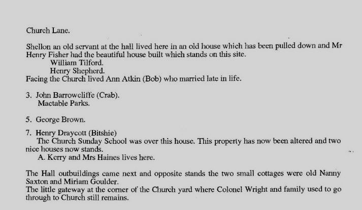
Stapleford is very fortunate to have on record James Choulerton’s memories. (See the ‘Histories and Memories’ section of this website.) link They were written in December 1926 when James was 66 years old and contain much fascinating detail about Stapleford and its inhabitants including a street by street account of who lived where. It is sometimes difficult to date his comments but its 25 pages add significantly to our knowledge of bygone Stapleford. Here is a copy of what he has to say about Church Lane.
Enclosure Award and map of 1772.
Notts Archives. A comprehensive description of Stapleford in 1772 showing the enclosure of the old open fields, Bridge Field, Windmill Field and Hill Field and who owned Stapleford thereafter.
Conservation area
Church Lane is included in one of the Broxtowe District Council Conservation Areas. Further details can be found here.link
St. Helen’s Church.
The history of St. Helen’s Church has been extensively researched, most recently as part of the Diocese of Southwell and Nottingham Church History Project. A link to St. Helen’s can be found here.link
The Cross
The definitive work on the cross is by Paul Everson and David Stocker in their 2015 book ‘Corpus of Anglo-Saxon Stone Sculpture. XII: Nottinghamshire, (Oxford: British Academy and Oxford U.P., 2015’ and briefly summarised with permission in No. 38 of the Stapleford Local History Society Newsletter. link
There are a number of other sources used and these will be referenced as a footnote to the text.
On a number of occasions it has been necessary to make guesses, interpretations and conjectures. If you draw different conclusions from the evidence then please let us know via the tab below. These notes can be easily amended.
Footnotes
Click on footnote to return to main text.